


Deep backcountry canyons and dense forest canopies often turn standard smartphone mapping apps into battery-draining dead weight. Dedicated outdoor navigators provide reliable satellite reception without relying on cellular towers or fragile glass screens. Selecting the best handheld gps camping hiking unit ensures you maintain clear waypoints, reliable elevation data, and track-back guidance during remote trail outings. Reliable navigation pairs directly with trail essentials, whether packing a reliable shelter or stowing a best canteen for boiling water in your pack for quick hydration stops.
Sunlight readability and rugged weather resistance separate dedicated trail navigators from basic electronic gadgets. Available units range from straightforward track loggers to multi-band GNSS receivers with routable topographic maps and barometric sensors. Checking battery endurance, satellite network compatibility, and physical button controls helps campers avoid unexpected route errors in adverse weather. Investing in dependable navigation gear keeps your route secure so you can relax around camp in a comfortable camping chair after a long trek across difficult terrain.
Pros
- Multi-band satellite tracking maintains strong signal lock under heavy tree canopies and steep topography
- Includes preloaded TopoActive maps and U.S. public land boundaries straight out of the box
- Button-operated interface functions reliably in rain, snow, and while wearing bulky winter gloves
- Lightweight 0.48-pound construction makes it easy to carry on long-distance backcountry treks
Cons
- The 2.6-inch screen provides a smaller viewing area compared to modern smartphone displays
- Button-based interface requires a slight learning curve for users accustomed to touchscreens
- Full waypoint syncing and cloud route planning require a separate compatible smartphone running the Garmin Explore app
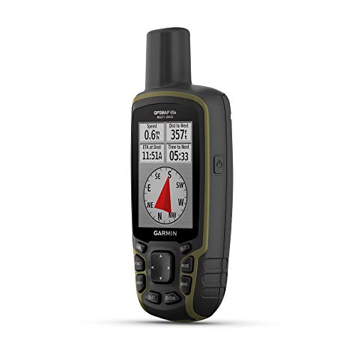
The Garmin GPSMAP 65s is a dedicated outdoor handheld GPS navigator engineered for reliable route tracking in remote wilderness settings. Built around a classic button-operated form factor, this device serves backpackers, hikers, hunters, solo adventurers, and overlanders who need accurate navigation independent of cellular coverage. For outdoor enthusiasts traversing thick timber, steep mountain ridges, or expansive public lands, having a standalone navigation device eliminates the battery drain and fragile glass vulnerabilities of standard smartphones.
In challenging outdoor environments, satellite signal attenuation can complicate route finding. The GPSMAP 65s counteracts signal interference by utilizing multi-band technology and expanded GNSS support, enabling the receiver to access multiple frequencies from satellite constellations. Supported by an internal 3-axis tilt-compensated electronic compass and a barometric altimeter, users can track subtle barometric pressure trends for weather shifts, measure accurate elevation profiles, and maintain a precise heading even while standing completely still on an unmarked trail.
The unit comes equipped with routable TopoActive mapping and federal public land map data for the United States. Having preloaded terrain contours, geographic points, and public boundary lines directly on the device assists dispersed campers, hunters, and hikers in verifying land access on the fly. The 2.6-inch color display is designed for outdoor legibility, remaining sunlight-readable in bright midday exposure where standard mobile devices often suffer from severe glare and screen washout.
Measuring 7.04 by 5.44 by 2.29 inches and weighing only 0.48 pounds, the GPSMAP 65s fits comfortably in a pack lid, shoulder harness pouch, or jacket pocket. Physical push buttons located below the screen give outdoorsmen full operational control during heavy downpours, freezing mornings, and muddy trail conditions where touchscreen devices frequently fail or register phantom inputs. When paired with a compatible smartphone, the Garmin Explore app facilitates off-trail waypoint management, route review, and data backup once you return to basecamp or a vehicle.
While the hardware is built for rigorous outdoor handling, potential buyers should recognize the trade-offs of a compact, dedicated GPS unit. The 2.6-inch screen requires deliberate panning and zooming when studying expansive trail networks compared to large tablet or phone screens. For backcountry hikers, solo backpackers, and emergency-preparedness planners seeking dependable tracking and pinpoint location accuracy in dense cover, the Garmin GPSMAP 65s stands as a practical, trail-ready navigation instrument.
Multi-band GNSS technology allows the Garmin GPSMAP 65s to track multiple navigation satellite frequencies simultaneously, delivering optimal positioning accuracy in steep mountain terrain, deep ravines, and dense forest canopies.
With preloaded TopoActive maps and U.S. federal public land boundaries, campers and hunters can reference elevation contours, summits, trails, and public-versus-private land borders directly from the field without requiring an active cellular connection.
Weighing only 0.48 pounds, this handheld GPS unit adds minimal weight to a multi-day backpacking pack, chest rig, or car camping glove compartment.
The durable exterior casing and tactile push-button interface ensure seamless operation in freezing weather, mud, and rainstorms where touchscreens become difficult to operate with wet or gloved hands.

Pros
- Multi-band GNSS technology helps maintain satellite lock in challenging deep timber and mountain ravines.
- Includes preloaded routable TopoActive cartography and U.S. federal public land boundary data right out of the box.
- Tactile push-button interface functions smoothly during cold weather or rainfall when touchscreens become difficult to operate.
- Compact 0.48-pound build adds minimal weight to a hiking pack or field belt.
Cons
- The 2.6-inch display is compact compared to modern smartphone screens, requiring more scrolling to view extensive map sections.
- Button-based text entry for naming waypoints can be slower than typing on a touchscreen device.
- Requires smartphone pairing and cellular coverage prior to your trip to sync data with the Garmin Explore app.
The Garmin GPSMAP 65 is a rugged, button-operated handheld GPS unit engineered specifically for off-grid backcountry navigation and outdoor exploration. Designed for backpackers, solo hikers, overlanders, hunters, and experienced outdoorsmen, this unit serves as a dedicated navigation lifeline when smartphone batteries drain or cellular towers fall out of range. Built with an ergonomic outdoor chassis measuring 6.3 by 2.4 by 1.4 inches and weighing just 0.48 pounds, it fits naturally into a daypack pocket or clips securely to a pack strap.
Real-world trail performance hinges on satellite reception, and the GPSMAP 65 addresses deep-timber reception drops with expanded Global Navigation Satellite Systems (GNSS) support and multi-band technology. By utilizing multiple satellite frequencies simultaneously, the unit delivers consistent positional accuracy in challenging environments like steep mountain drainages, narrow ravines, and heavy hardwood canopies where standard single-frequency units might drift. Backcountry travelers can navigate remote switchbacks or retrace steps back to a dispersed campsite at dusk with dependable location tracking.
The device features a 2.6-inch sunlight-readable color display that remains legible under direct sun, eliminating the washed-out glare common to glass smartphone screens. Out of the box, it includes routable TopoActive mapping along with federal public land maps for the United States, providing clear visibility of national park borders, forest service boundaries, elevation contours, and established trails. Unlike touch-sensitive screens that can misfire in driving rain or fail with wet gloves, the tactile front push-buttons offer reliable control whether you are weathering a sudden mountain downpour or navigating in freezing morning frost.
Planning extended routes and managing waypoints is straightforward thanks to compatibility with the Garmin Explore mobile app and web platform. Campers and hikers can plan routes in advance on a compatible smartphone, mark water sources or hunting blinds, and review travel statistics once synchronized. At less than half a pound, the device introduces virtually no carrying penalty on multi-day backpacking trips, yet the exterior casing feels sturdy enough to handle the bumps, drops, and abrasions common to rocky scramble routes and rugged timber trails.
While the GPSMAP 65 excels at reliable satellite tracking, buyers should consider its operational interface. The 2.6-inch screen is noticeably smaller than modern smartphones, meaning that panning across broad regional maps takes extra patience. Additionally, entering custom waypoint names or trail notes using directional buttons requires more clicks and time compared to an on-screen keyboard. Users will also want to ensure they download desired routes and map regions before departing trailhead cell coverage, as deep backcountry synchronization requires prior setup.
For weekend backpackers, remote hunters, off-grid campers, and emergency preparedness enthusiasts seeking reliable orientation away from paved roads, the Garmin GPSMAP 65 represents a practical, dependable field tool. Its blend of multi-band precision, preloaded public land boundaries, and all-weather button usability makes it a solid investment for anyone who prioritizes backcountry safety and accurate route finding over touchscreen convenience.
The Garmin GPSMAP 65 comes preloaded with routable TopoActive maps and U.S. federal public land boundaries, giving campers and hikers instant access to trail routes, terrain contours, and land ownership information. This setup helps outdoor enthusiasts identify whether a potential dispersed campsite sits on public Bureau of Land Management ground, national forest land, or private property.
Equipped with expanded GNSS support and multi-band technology, the unit tracks multiple frequencies to improve positioning in dense woods and steep canyons. Paired with the Garmin Explore app, adventurers can organize waypoints, plot future hiking tracks, and review route elevation profiles right from the field when connected to a compatible smartphone.
Engineered for all-weather outdoor use, the GPSMAP 65 relies on traditional tactile push buttons rather than a touchscreen. This design choice prevents accidental screen inputs from rain droplets and allows smooth menu navigation while wearing thick cold-weather camping gloves.
The sunlight-readable 2.6-inch color screen maintains sharp contrast during bright mid-day hikes across open ridges. Weighing just 0.48 pounds, the unit adds minimal base weight to a backpacking gear list, easily fitting into pack hip-belt pockets, jackets, or chest harnesses for quick trail checks.

Pros
- Multi-GNSS support across four satellite networks improves location acquisition in dense timber and steep terrain.
- Rechargeable battery delivers up to 20 hours of continuous tracking via standard USB-C charging.
- Slim, lightweight dimensions make it comfortable to carry in a pocket or backpack hip belt.
- Built-in track logging and waypoint storage provide straightforward backtrack navigation to trailheads.
Cons
- Does not include preloaded topographic or street maps, displaying only breadcrumb tracks and waypoints.
- Requires open-sky satellite acquisition prior to entering thick tree cover to achieve accuracy below 1 meter.
- Technical specifications do not document a specific IP waterproof rating for severe storm exposure.
The NiesahYan A6 is a dedicated handheld GPS navigator engineered for hikers, backpackers, solo adventurers, and outdoor explorers seeking essential position tracking without complex mapping interfaces. Designed with a slim, portable form factor, this unit caters to budget-conscious campers, weekend trail hikers, and emergency preparedness planners who need dependable coordinate tracking and return-to-camp directions. Rather than draining smartphone batteries on backcountry routes, having a standalone navigation device helps wilderness travelers maintain directional awareness across extended treks.
Positional reliability stems from its multi-GNSS architecture, which accesses four satellite systems: GPS, Galileo, BeiDou, and QZSS. This multi-constellation support allows the unit to maintain satellite reception in challenging environments like steep canyons, dense mountain timber, and rugged terrain where single-network receivers often struggle. The bright 2.4-inch color screen clearly displays heading information from an integrated GPS compass and elevation changes via a barometric altimeter, while sunrise and sunset calculators give backpackers actionable data to pitch tents before twilight.
Field readiness is supported by a built-in rechargeable battery delivering up to 20 hours of continuous runtime. Utilizing a standard USB-C port, the device can be easily refreshed at camp using a portable power bank, solar charger, or vehicle outlet. Measuring 6.1 x 0.9 x 2.1 inches, the compact housing slips effortlessly into a backpack hip-belt pocket, shoulder strap pouch, or emergency kit without adding substantial bulk to your trail pack weight.
Navigational functionality centers on active track recording and waypoint management. Hikers can log trail paths from the start of a hike, mark crucial water sources, campsite clearings, or trail forks, and rely on the backtrack feature to guide them back to their original trailhead if visibility drops. Because the system tracks breadcrumb vectors rather than relying on cellular towers, it remains functional far beyond cell service boundaries, making it a practical backup tool when navigating off-grid public lands or national forests.
A primary limitation is the total absence of preloaded or downloadable base maps. The display presents coordinate data, waypoints, and vector lines rather than topographic terrain or trail maps, meaning users should pair this unit with paper topo maps or offline mobile maps for comprehensive route planning. Additionally, the manufacturer advises acquiring satellite signals under an open sky until the signal indicator registers below 1 meter before setting out into heavy tree cover. For backpackers and hikers seeking an affordable, long-lasting electronic compass, altimeter, and breadcrumb tracker to safeguard their wilderness journeys, the NiesahYan A6 offers solid utilitarian value.
Operating the NiesahYan A6 begins by powering on the device under an open expanse of sky to ensure rapid satellite acquisition across its four GNSS networks. The manufacturer notes that users should wait until the signal value displayed in the upper-left corner of the screen registers below 1 meter before heading beneath heavy tree canopy or into steep terrain.
Once satellite communication is established, users can activate track recording to trace continuous footsteps along the trail. Marking key waypoints along the route allows hikers to pinpoint campsites, water caches, or trail junctions, while the built-in backtrack function offers direct heading guidance back to the starting point whenever orientation is compromised.
With an elongated footprint of 6.1 x 0.9 x 2.1 inches, this handheld navigator is designed for single-handed operation and effortless packability. It fits comfortably into standard backpack pockets, chest rigs, or camp storage pouches without demanding significant pack volume.
The integrated rechargeable battery provides up to 20 hours of continuous tracking, reducing dependency on disposable AA batteries. Standard USB-C connectivity allows backcountry campers and overlanders to top off the unit using modern solar panels or portable power banks during multi-day excursions.

Pros
- Multi-GNSS connectivity links to four satellite networks for fast location acquisition and high positional accuracy
- Physical push buttons provide reliable tactile control when hands are cold, sweaty, or gloved
- Preloaded USA Topo mapping combined with 32 GB internal memory provides trail navigation right out of the box
- Rechargeable battery provides up to 36 hours of off-grid runtime and charges via universal USB-C power sources
- IP66 water-resistant housing and anti-slip grip hold up against trail splashes and surprise rainstorms
Cons
- IP66 rating protects against heavy rain and water jets but does not support full underwater submersion
- Internal rechargeable battery cannot be swapped in the field with standard AA batteries without a portable power bank
- The 3.2-inch screen is compact for lightweight packability but provides a smaller map viewing area than a modern smartphone
The NiesahYan Handheld GPS Navigator is an electronic outdoor navigation unit tailored for hikers, backcountry backpackers, solo explorers, and hunters navigating away from cell towers. For adventurers journeying beyond cellular coverage, relying solely on mobile phones can present serious battery drain and signal risks. This dedicated GPS unit fills that critical backcountry safety role by delivering standalone satellite positioning, onboard topographic charts, and robust waypoint navigation in a handheld format built specifically for remote wilderness travel.
In terms of field usability, the unit features a bright 3.2-inch display designed to remain readable under harsh mid-day sunlight. Unlike capacitive smartphone touchscreens that frequently glitch when hit with raindrops or handled with insulated gloves, this device relies on tactile physical buttons and an anti-slip chassis. This physical control layout allows hikers to mark trail forks, check bearings, or view track-back routes while wearing winter gloves or navigating through soaking mountain rain.
Positional performance centers on multi-GNSS satellite tracking, drawing signals simultaneously from GPS, GALILEO, BEIDOU, and QZSS constellations. According to product specifications, this multi-network reception provides location precision down to 6 feet, even when trekking through steep canyons or heavy forest canopies. The system comes preloaded with USA Topo maps and includes 32 GB of internal storage for saving routes or downloading additional regional charts. Navigation is further supported by an integrated 3-axis digital compass that maintains an accurate heading while standing stationary, alongside a barometric altimeter to track elevation gain along mountain passes.
Power management and weather resistance match the demands of multi-day trail excursions. The navigator houses an integrated rechargeable battery rated for up to 36 hours of runtime on a full charge, easily topped off around camp using a standard USB-C cable and a portable power bank. Its exterior casing carries an IP66 water-resistance rating, meaning it easily sheds driving rain, mud splashes, and trail grit. While IP66 handles torrential rain and pressurized water spray with ease, it is water-resistant rather than fully submersible, so dropping it into deep stream crossings should be avoided.
Long-term care and outdoor handling remain straightforward. Keeping the USB-C port cover firmly seated preserves moisture resistance on the trail, while wiping down the screen and buttons with a damp microfiber cloth prevents trail dust from grinding into the casing. Because the internal rechargeable battery cannot be swapped out for disposable AA cells, packing a small power bank is advisable for week-long treks.
For outdoor enthusiasts planning backcountry hikes, dispersed camping trips, or overlanding routes where phone signals vanish, the NiesahYan navigator provides dependable standalone navigation. While users seeking tablet-sized digital displays might find the 3.2-inch screen compact, its combination of multi-GNSS tracking, preloaded maps, and resilient physical controls makes it a practical navigation companion for any wilderness outing.
This navigator integrates multi-GNSS support across GPS, GALILEO, BEIDOU, and QZSS satellite arrays, establishing positioning precision down to 6 feet according to product specifications. The multi-satellite framework provides faster signal acquisition and consistent tracking under dense tree cover or inside rocky ravines compared to single-network GPS units.
With preloaded USA Topo maps and 32 GB of onboard internal storage, users have immediate access to contour lines and trail paths right out of the box. An onboard 3-axis electronic compass delivers real-time orientation bearings without requiring forward movement, while the barometric altimeter tracks atmospheric pressure shifts to deliver reliable ascent and elevation metrics.
Built with an IP66 water-resistant rating, this handheld navigator is engineered to withstand heavy trail downpours, salt spray, mud, and dust storms. The rugged exterior features anti-slip texturing along the sides, minimizing drops when handling the device with wet hands or thick trekking gloves.
Although rated to withstand powerful water jets and harsh mountain storms, the unit is not certified for prolonged underwater submersion. Outdoorsmen should ensure the silicone USB-C port cover remains seated securely during rainstorms and consider stowing the device in an exterior pack pocket or tethering it with a lanyard across technical terrain.

Pros
- Combines dual-satellite GPS and BeiDou positioning with a Swiss barometric altimeter for reliable altitude and trail tracking.
- Logs historical pressure trends over 24-hour and 7-day intervals, providing useful advance notice of approaching storm fronts.
- Internal lithium battery recharges via an included standard USB cable, reducing disposable battery waste on the trail.
- High-visibility black and orange ABS casing is lightweight, durable, and easy to locate in low-light camp settings.
Cons
- IPX4 rating safeguards against rain and splashing water but will not protect against full stream submersion.
- Digital data interface displays coordinates and direction vectors rather than full color topographic maps.
- Extended multi-day backcountry treks require carrying an external USB power bank to recharge the internal battery.
The JuviPerpric Handheld Multifunction Digital Altimeter is a multi-sensor outdoor navigation instrument designed to give hikers, backpackers, and mountaineers instant access to critical terrain and atmospheric data. Powered by dual GPS and BeiDou satellite positioning, this compact device pairs satellite coordinate logging with an internal Swiss barometric sensor to deliver accurate elevation readings. It serves as a dependable field resource for solo adventurers, weekend warriors, alpine climbers, and search-and-rescue teams who want essential geographic tracking without relying on spotty smartphone cellular connections.
Elevation tracking and barometric monitoring are vital functions when hiking steep ridges or setting up camp in changing mountain weather. Based on product specifications, the Swiss sensor measures altitude with a precision of 0.5 to 1 meter, toggleable between meters and feet, and features an adjustable altitude warning from 1 to 200 meters. The unit logs historical trend curves every 30 minutes over 24-hour and 7-day spans. This historical trend tracking allows campers to identify sudden barometric pressure drops that frequently precede bad weather, providing ample time to secure tent guylines and batten down the campsite rainfly before precipitation hits.
For trail orientation and climate awareness, the unit features an electronic 16-point compass with horizontal calibration alongside an integrated thermometer and hygrometer. The lightweight ABS body sports a high-contrast black and orange finish that prevents it from getting lost in leaf litter or inside a dark backpack compartment. An IPX4 water resistance rating ensures protection against wind-blown rain, sleet, and splashing water, while a wide operating temperature range of -20 degrees Celsius to 60 degrees Celsius supports cold-weather snowshoeing and hot desert treks alike. A built-in LED torch and a 5-second backlit display provide quick illumination when reading coordinates after twilight or checking tent stakes in the middle of the night.
Power maintenance on extended trips is simple thanks to the internal lithium battery, which charges through the included USB cable. Rather than packing boxes of alkaline batteries into the backcountry, hikers can replenish the device using a portable power station, car charger, or backpacking solar panel. A practical limitation to keep in mind is that the high-contrast display provides numerical coordinates, bearings, and route-return markers rather than full-color topographic mapping. Long-distance trekkers should treat this unit as an active telemetry tool and compass complement alongside traditional paper topo maps.
The JuviPerpric Digital Altimeter delivers a strong balance of multi-sensor data tracking, rugged weather resistance, and pocket-sized portability for budget-conscious hikers, family campers, and emergency preparedness planners. Its ability to record historical elevation, track return routes, and monitor barometric pressure trends makes it a valuable safety companion on any trail. For anyone looking to monitor altitude, navigate off-grid routes, and prepare for shifting weather fronts, this device provides genuine outdoor value in an accessible handheld format.
The JuviPerpric handheld navigator relies on a dual-satellite architecture combining GPS and BeiDou systems with a stated accuracy of 1 meter. This setup supports real-time speed, total distance covered, and up to 9 route-tracking and return records, allowing hikers to mark waypoints and trace their path back to camp even in remote backcountry valleys. The 16-point electronic compass includes horizontal calibration to ensure directional precision when navigating off established trails.
Environmental monitoring is driven by a precision Swiss sensor that records barometric pressure, relative humidity, and ambient temperature. The system translates atmospheric shifts into short-term weather forecasts, while the 30-minute interval logging provides 24-hour and 7-day trend analysis. These combined metrics help outdoorsmen assess approaching low-pressure systems, monitor elevation changes during steep climbs, and adjust pace and shelter plans accordingly.
Engineered for rugged outdoor handling, the unit features a durable ABS shell designed to absorb trail impacts without adding excessive pack weight. With an IPX4 waterproof rating, the device easily manages falling rain, melting snow, and water splashes, keeping internal sensors functional throughout unpredictable mountain storms. The wide operating temperature threshold from -20 degrees Celsius to 60 degrees Celsius ensures consistent performance from freezing alpine mornings to scorching mid-summer hikes.
Field illumination and battery efficiency are built directly into the housing. The 5-second screen backlight provides rapid reading in complete darkness without draining the rechargeable lithium cell prematurely, while the integrated front-facing LED torch serves as a reliable emergency light source for navigating campsites or signaling after dark. Recharging via a standard USB cable means simple power integration with existing camp power banks and solar gear.
Frequently Asked Questions
How does multi-band satellite technology improve accuracy in dense forest terrain?
Multi-band GNSS technology tracks multiple radio frequencies per satellite constellation simultaneously to reduce signal reflection errors. In steep valleys, canyon walls, and dense tree cover, standard single-frequency signals often bounce off obstacles before reaching the receiver antenna. Multi-band units filter out these distorted multipath signals, narrowing positional drift down to a few feet. Navigators like the Garmin GPSMAP 65 series utilize multi-band support to maintain steady coordinate locks where older receivers struggle.
Do all handheld GPS navigators come preloaded with topographic maps?
No, basic GPS units frequently use breadcrumb tracking rather than full topographic map displays. Compact models often record waypoints and provide digital compass headings to guide you back to your starting point without rendering contour lines or roads. Full-featured navigators include preloaded topographical maps and onboard memory for downloadable map layers. Hikers relying on mapless models must ensure satellite locks are fully acquired in open skies before setting off.
Why are physical button controls preferred over touchscreens for hiking navigation?
Physical push buttons operate reliably in freezing temperatures, heavy rain, and while wearing bulky trail gloves. Capacitive touchscreens can misregister inputs or lock up entirely when wet with rain or coated in trail mud. Dedicated buttons let you zoom maps, drop coordinate markers, and toggle pages without exposing your hands to cold weather. Rugged outdoor models stick with tactile buttons so changing weather conditions do not disrupt trail navigation.
What is the difference between a GPS compass and a 3-axis electronic compass?
A 3-axis electronic compass provides an accurate heading while you are standing completely stationary, whereas a GPS compass requires forward motion to determine direction. Electronic compasses use internal magnetic sensors that function regardless of how you tilt the device. In contrast, GPS-only compasses calculate your heading by measuring position changes over time. Having an integrated sensor compass simplifies orienting your map at confusing trail junctions before taking another step.
How should hikers manage battery life during extended backcountry trips?
Managing screen backlight timeout and packing dedicated power banks provides dependable power across multi-day trips. Handheld navigators featuring USB-C ports recharge easily from portable power packs, while button-operated screens often deliver between 20 and 36 hours of continuous tracking. Lowering screen brightness and disabling unused sensors extends operating time significantly in the field. Pairing your electronics strategy with camp essentials like a water storage container for emergencies ensures overall preparedness throughout remote wilderness adventures.


Write Your Review
No reviews yet. Be the first to share your experience!